Chimani App Review: Is It the Ultimate National Park Guide?
Have you ever wandered through majestic redwood groves or scaled the frosted heights of Glacier National Park with only a crumpled paper map for company? If you’re anything like me, the thrill of outdoor adventure is matched only by the anxiety of getting lost, missing hidden gems, or—worst of all—fighting spotty cell service with Google Maps gasping for signal. Enter Chimani: an app promising seamless, offline, and detailed experiences in America’s great outdoors. But does it live up to the hype as the ultimate national park guide?
What Is Chimani?
Chimani is a mobile app purpose-built for national park enthusiasts, whether you're a casual stroller in Yosemite Valley or a full-throttle backcountry trekker. Founded by a group of park lovers in Maine, the app claims to cover all 425+ sites of the U.S. National Park Service. Unlike the one-size-fits-all travel apps, Chimani zeroes in with park-specific features—trail maps, activity suggestions, amenity locations, current alerts, and even audio tours—all offline ready.
Key Features at a Glance
| Feature | Description | Offline Capability |
|---|---|---|
| Interactive Maps | Detailed, park-specific trail and site maps with GPS locate | ️ |
| Park Guides | Comprehensive guides for activities, facilities, notable sights | ️ |
| Audio Tours | Professional-grade audio guides for self-touring | ️ |
| Live Updates | Real-time park alerts, closures, and news | |
| User Account & Rewards | Record visits, earn virtual badges, trip journal features | ️ (some features require sign-in) |
First Impressions: Setup and Navigation
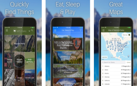
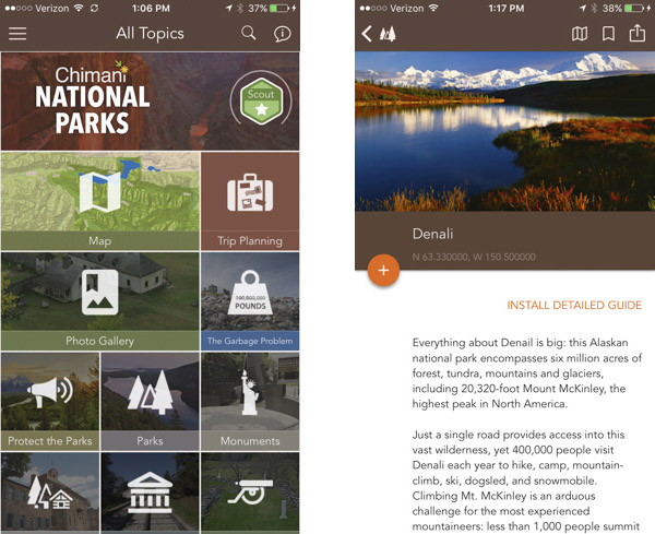
Chimani greets you with vibrant images and a smooth onboarding. Account setup is fast (optionally connect with email, Google, or Apple)—within two minutes, I comfortably surfed to my favorite park, Grand Teton.
The homepage prioritizes parks nearest you, with bold icons for Map, Explore, Audio, and Passport. The app’s clean interface deserves applause—no advertising clutter, logical menu flow, and highly readable, even in sunlight.
Pro Tip:
- Download guides before entering the park. Cell coverage is unreliable; this prep step is gold.
Chimani in Action: Real Life Case Studies
Case 1: Navigating Bryce Canyon’s Queens Garden Trail
Travel blogger Ava recounts: “Midway through Bryce in a June heatwave, our paper map wilted and the cell signal vanished. Chimani’s GPS pinpointed us on the Queens Garden Trail, not only reassuring us but also flagging a shady rest spot and a stunning off-trail lookout that my guidebook missed.”
Case 2: Family Roadtrip in Acadia National Park
The Chen family, rookies to park travel, used Chimani for Acadia. “With two kids, we loved the audio tour—educational, fun, and kept the whole car engaged. The kids collected virtual badges for finishing hikes, which made them eager to explore more.”
Case 3: Off-the-Grid at Joshua Tree
Solo backpacker Marcus recalls: “Chimani’s offline map saved me when I took the wrong fork among the boulders. It snapped my blue dot right back on course, and the ‘Things to Do’ list led me to a near-solitary stargazing hill I’d never find otherwise.”
Content-Rich Exploration: Features Deep Dive
1. Interactive Park Maps
- Every national park has its own map, layered with trails, amenities, parking, and points of interest
- GPS tracking works offline
- Tap on icons for pop-up facts, restroom locations, picnic areas, and more
2. Audio Tours
- Professionally narrated stories add depth, history, and quirky facts
- Available for top parks, with expanding library
- Use Bluetooth for car speakers or headphones
3. Passport & Badges
- Digital log of your park visits, trails hiked, and activities completed
- Earn unique badges for milestones—perfect for motivating kids (or competitive adults)
- Share your adventures with friends in-app or on social
4. Park Alerts & News
- Live updates about weather hazards, Covid rules, wildlife, and closures
- Note: Requires data connection
Information Increment: What Sets Chimani Apart?
Many navigation and travel apps tout offline maps, but Chimani’s laser focus on parks gives it a depth competitors don’t match. Most notably:
- 100% Offline Park Experience: Download once, and you’re free from the grid.
- No Ads: A surprisingly rare thing—enjoy distraction-free trip planning.
- Locally Curated Content: Each park guide draws from real park rangers, historians, or local experts.
- National Park Passport Integration: It aligns with popular physical park passports, digitizing visits for collectors.
Comparison Table: Chimani vs. Top Competitors
| App | Offline Maps | Audio Guides | No Ads | Park-Specific Info | Price (Basic) |
|---|---|---|---|---|---|
| Chimani | ️ | ️ | ️ | ️ | Free (+ Premium from $30/yr) |
| AllTrails | ️ (with Pro) | Some | Free / Pro $36/yr | ||
| REI Co-op National Parks | ️ | ️ | Limited | Free | |
| NPS (Official) | ️ | ️ | ️ | Free |
User Experience: The Good, The Bad, and the Surprising
What Users Love
- No Signal, No Problem: Maps and guides work deep in canyons and forests
- Easy to Use: Simple interface for all age groups
- Regular Updates: App evolves with new parks, features, and tour content
- Personalization: Trip logging, badges, and customized favorites lists
User Gripe List
- Premium Required for Some Audio and Future Content: While most features are free, full audio libraries and new deep-dive guides are locked behind Chimani Perks
- Battery Drain: Like all GPS apps, extended use can hurt battery life—carry a power bank
- Occasional Map Lag: A few users note sluggishness when zooming or switching between parks on older phones
Frequently Asked Questions (FAQ)
Final Verdict: Should You Use Chimani?
If your heart skips a beat seeing a national park gate or your bucket list overflows with nature’s wonders, Chimani is a valuable trail companion. Its offline-first approach, detailed resources, and playful touches (badges! logs! audio!) stand out in a crowded app landscape.
While premium add-ons are tempting for frequent explorers, most casual visitors will find the free version robust enough to make their next national park trip smoother, safer, and more enriching. A little power-bank planning and some pre-trip downloads, and you’re set to wander with confidence.
What About You?
What’s your most unforgettable national park experience, and which tool (digital or otherwise) saved your trip? Share your stories—or your must-visit park—in the comments below!